Earth's Major Geological Hazards
VOLCANOES
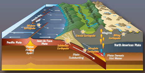
An active volcano occurs when magma (molten rock) reaches the earth's surface through a crack or vent in the crust. Volcanic activity can involve the extrusion of lava on the surface, the ejection of solid rock and ash, and the release of water vapor or gas (carbon dioxide or sulfur dioxide). Volcanoes commonly occur near plate boundaries where the motion of the plates has created cracks in the lithosphere through which the magma can flow. About eighty percent of volcanoes occur at convergent plate boundaries where subducted material melts and rises through cracks in the crust. The Cascade Range was formed in this way.
VOLCANOES
An active volcano occurs when magma (molten rock) reaches the earth's surface through a crack or vent in the crust. Volcanic activity can involve the extrusion of lava on the surface, the ejection of solid rock and ash, and the release of water vapor or gas (carbon dioxide or sulfur dioxide). Volcanoes commonly occur near plate boundaries where the motion of the plates has created cracks in the lithosphere through which the magma can flow. About eighty percent of volcanoes occur at convergent plate boundaries where subducted material melts and rises through cracks in the crust. The Cascade Range was formed in this way.
|
|
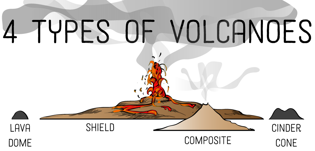
Volcanoes can be classified according to the type and form of their ejecta. The basic types are: composite volcanoes, shield volcanoes, cinder cones, and lava domes.
Composite volcanoes are steep-sided, symmetrical cones built of multiple layers of viscous lava and ash. Most composite volcanoes have a crater at the summit which contains the central vent. Lavas flow from breaks in the crater wall or from cracks on the flanks of the cone. Mt Fuji in Japan and Mt Ranier in Washington are examples of composite volcanoes.
Shield volcanoes are built almost entirely of highly fluid (low viscosity) lava flows. They form slowly from numerous flows that spread out over a wide area from a central vent. The resultant structure is a broad, gently sloping cone with a profile like a warrior’s shield. Mt Kilauea in Hawaii is an example of a shield volcano.
Cinder cones are the simplest type of volcano. They form when lava blown violently into the area breaks into small fragments that solidify and fall as cinders. A steep-sided cone shape is formed around the vent, with a crater at the summit. Sunset Crater in Arizona is a cinder cone that formed less than a thousand years ago, disrupting the lives of the native inhabitants of the region.
Lava domes are formed when highly viscous lava is extruded from a vent and forms a rounded, steep-sided dome. The lava piles up around and on the vent instead of flowing away, mostly growing by expansion from within. Lava domes commonly occur within the craters or on the flanks of composite volcanoes.
Volcanic Hotspots
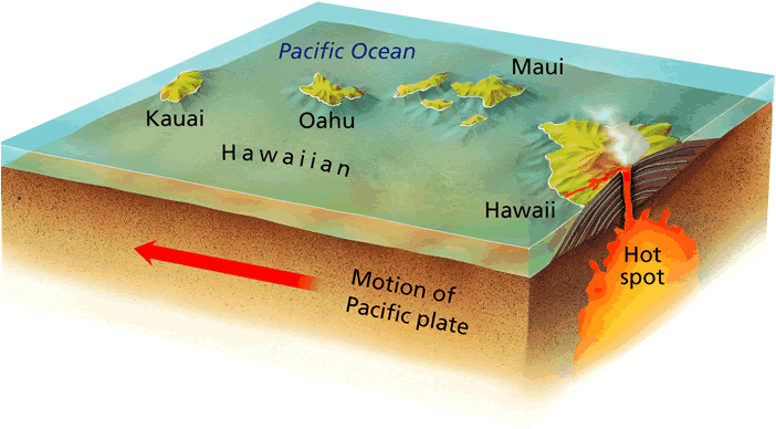
Although most volcanoes are found at convergent or divergent plate boundaries, intraplate volcanoes are found in the middle of a tectonic plate. Why is there melting at these locations? The Hawaiian Islands are the exposed peaks of a great chain of volcanoes that lie on the Pacific plate. These islands are in the middle of the Pacific plate. The youngest island sits directly above a column of hot rock called a mantle plume. As the plume rises through the mantle, pressure is released and mantle melts to create a hotspot (Figure below).
Although most volcanoes are found at convergent or divergent plate boundaries, intraplate volcanoes are found in the middle of a tectonic plate. Why is there melting at these locations? The Hawaiian Islands are the exposed peaks of a great chain of volcanoes that lie on the Pacific plate. These islands are in the middle of the Pacific plate. The youngest island sits directly above a column of hot rock called a mantle plume. As the plume rises through the mantle, pressure is released and mantle melts to create a hotspot (Figure below).
Supervolcanoes
Supervolcano eruptions are extremely rare in Earth history. It’s a good thing because they are unimaginably large. A supervolcano must erupt more than 1,000 cubic km (240 cubic miles) of material, compared with 1.2 km3 for Mount St. Helens or 25 km3 for Mount Pinatubo, a large eruption in the Philippines in 1991. Not surprisingly, supervolcanoes are the most dangerous type of volcano.
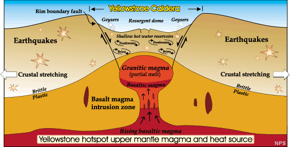
Supervolcanoes are a fairly new idea in volcanology. The exact cause of supervolcano eruptions is still debated. However, scientists think that a very large magma chamber erupts entirely in one catastrophic explosion. This creates a huge hole or caldera into which the surface collapses (Figure below).
The largest supervolcano in North America is beneath Yellowstone National Park in Wyoming. Yellowstone sits above a hotspot that has erupted catastrophically three times: 2.1 million, 1.3 million, and 640,000 years ago. Yellowstone has produced many smaller (but still enormous) eruptions more recently (Figure below). Fortunately, current activity at Yellowstone is limited to the region’s famous geysers.
Supervolcano eruptions are extremely rare in Earth history. It’s a good thing because they are unimaginably large. A supervolcano must erupt more than 1,000 cubic km (240 cubic miles) of material, compared with 1.2 km3 for Mount St. Helens or 25 km3 for Mount Pinatubo, a large eruption in the Philippines in 1991. Not surprisingly, supervolcanoes are the most dangerous type of volcano.
Supervolcanoes are a fairly new idea in volcanology. The exact cause of supervolcano eruptions is still debated. However, scientists think that a very large magma chamber erupts entirely in one catastrophic explosion. This creates a huge hole or caldera into which the surface collapses (Figure below).
The largest supervolcano in North America is beneath Yellowstone National Park in Wyoming. Yellowstone sits above a hotspot that has erupted catastrophically three times: 2.1 million, 1.3 million, and 640,000 years ago. Yellowstone has produced many smaller (but still enormous) eruptions more recently (Figure below). Fortunately, current activity at Yellowstone is limited to the region’s famous geysers.
|
|
While volcanic eruptions can be destructive, they do provide some benefits. They can result in the formation of majestic mountains and lakes, and the weathering of lava contributes to fertile soils. Hundreds of volcanoes have erupted on the ocean floor, building cones that have reached the ocean's surface, eventually to form islands that have become favorable for human settlement.
We can reduce the loss of human life and some of the property damage caused by volcanic eruptions in several ways. We use historical records and geological measurements to identify high-risk areas, so that people can avoid living in those areas. We also use monitoring devices that warn us when volcanoes are likely to erupt, and in some areas prone to volcanic activity, evacuation plans have been developed.
We can reduce the loss of human life and some of the property damage caused by volcanic eruptions in several ways. We use historical records and geological measurements to identify high-risk areas, so that people can avoid living in those areas. We also use monitoring devices that warn us when volcanoes are likely to erupt, and in some areas prone to volcanic activity, evacuation plans have been developed.
EARTHQUAKES
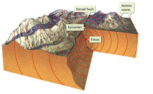
An earthquake occurs when built up strain in a rock mass causes it to rupture suddenly. The region where the rupture occurs is called the focus. This is often deep below the surface of the crust. The point on the surface directly above the focus is called the epicenter. Destructive waves propagate outward from the region of the quake, traveling throughout the earth. The magnitude of an earthquake is a measure of the total amount of energy released. The first step in determining the magnitude is to measure the propagated waves using a device called a seismograph. Based on this information, the earthquake is given a number classification on a modified Richter scale. The scale is logarithmic, so a difference of one unit means a difference of ten-fold in wave intensity, which corresponds to an energy difference of 32-fold. The intensity of an earthquake is an indicator of the effect of an earthquake at a particular locale. The effect depends not only on the magnitude of the earthquake, but also the types of subsurface materials and the structure and design of surface structures.
An earthquake occurs when built up strain in a rock mass causes it to rupture suddenly. The region where the rupture occurs is called the focus. This is often deep below the surface of the crust. The point on the surface directly above the focus is called the epicenter. Destructive waves propagate outward from the region of the quake, traveling throughout the earth. The magnitude of an earthquake is a measure of the total amount of energy released. The first step in determining the magnitude is to measure the propagated waves using a device called a seismograph. Based on this information, the earthquake is given a number classification on a modified Richter scale. The scale is logarithmic, so a difference of one unit means a difference of ten-fold in wave intensity, which corresponds to an energy difference of 32-fold. The intensity of an earthquake is an indicator of the effect of an earthquake at a particular locale. The effect depends not only on the magnitude of the earthquake, but also the types of subsurface materials and the structure and design of surface structures.
Earthquakes generally occur along breaks in the rock mass known as faults, and most occur in regions near plate boundaries. Some 80 percent of all earthquakes occur near convergent plate boundaries, triggered by the interaction of the plates. Earthquakes are also often associated with volcanic activity due to the movement of sub-surface magma.
Nearly 95% of all earthquakes take place along one of the three types of plate boundaries, but earthquakes do occur along all three types of plate boundaries.
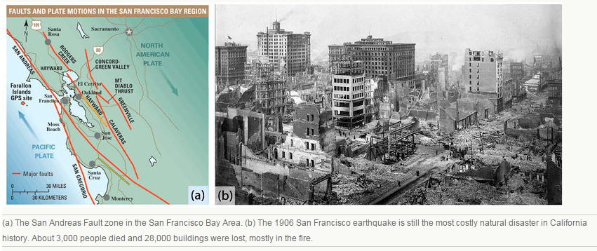
Deadly earthquakes occur at transform plate boundaries. Transform faults have shallow focus earthquakes. The faults along the San Andreas Fault zone produce around 10,000 earthquakes a year. Most are tiny, but occasionally one is massive. In the San Francisco Bay Area, the Hayward Fault was the site of a magnitude 7.0 earthquake in 1868. The 1906 quake on the San Andreas Fault had a magnitude estimated at about 7.9 (Figure below).
Nearly 95% of all earthquakes take place along one of the three types of plate boundaries, but earthquakes do occur along all three types of plate boundaries.
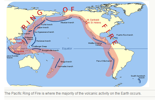
- About 80% of all earthquakes strike around the Pacific Ocean basin because it is lined with convergent and transform boundaries
- About 15% take place in the Mediterranean-Asiatic Belt, where convergence is causing the Indian Plate to run into the Eurasian Plate.
- The remaining 5% are scattered around other plate boundaries or are intraplate earthquakes.
Deadly earthquakes occur at transform plate boundaries. Transform faults have shallow focus earthquakes. The faults along the San Andreas Fault zone produce around 10,000 earthquakes a year. Most are tiny, but occasionally one is massive. In the San Francisco Bay Area, the Hayward Fault was the site of a magnitude 7.0 earthquake in 1868. The 1906 quake on the San Andreas Fault had a magnitude estimated at about 7.9 (Figure below).
One way to reduce the loss of life and property damage from earthquakes is to examine historical records and make geological measurements to locate active fault zones. We can then map high-risk areas and establish building codes that regulate the placement and design of buildings in such areas. Then people can evaluate risk and factor it into their decisions about where to live. Also, engineers know how to make homes, large buildings, bridges, and freeways more earthquake resistant, although this is costly.
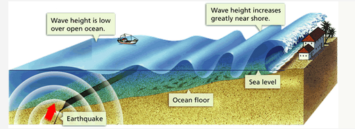
When an earthquake occurs under the ocean, it can trigger a destructive wave known as a tsunami. The sharp jolt of an undersea quake forms a set of waves that travel through the sea entirely unnoticed. When they come onto shore, they can grow to enormous heights. Fortunately, few undersea earthquakes generate tsunami.
When an earthquake occurs under the ocean, it can trigger a destructive wave known as a tsunami. The sharp jolt of an undersea quake forms a set of waves that travel through the sea entirely unnoticed. When they come onto shore, they can grow to enormous heights. Fortunately, few undersea earthquakes generate tsunami.
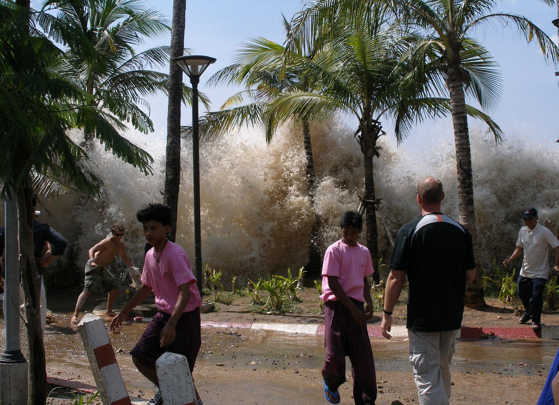
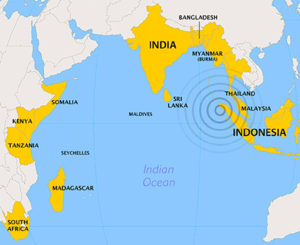
The largest recorded loss of life from a tsunami occurred in December 2004 when a great underwater earthquake in the Indian Ocean with a magnitude of 9.15 caused a tsunami with towering waves that killed around 279,900 people and devastated many coastal areas of Indonesia, Thailand, Sri Lanka, South India and even eastern Africa. It also displaced about 1.8 million people (1.3 million of them in India and Indonesia), and destroyed or damaged 470,000 buildings and houses. There were no recording devices in place to provide an early warning of this tsunami.
|
|
In 2011, a large tsunami caused by a powerful earthquake off the coast of Japan generated 3-story-high waves that killed almost 19,000 people, displaced more than 300,000 people, and destroyed or damaged 125,000 buildings. It also heavily damaged three nuclear reactors, which then released dangerous radioactivity into the surrounding environment.
In some areas, scientists have built networks of ocean buoys and pressure recorders on the ocean floor to collect data that can be relayed to tsunami emergency warning centers. However, these networks are far from complete.
In some areas, scientists have built networks of ocean buoys and pressure recorders on the ocean floor to collect data that can be relayed to tsunami emergency warning centers. However, these networks are far from complete.